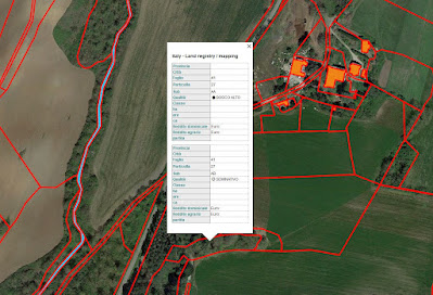
➡️ Offer collaboration full time for development of KML and ESRI® shapefile cartographic files using ArcGIS Pro software 🗺. Mapping of Italian cadastral parcels (land and buildings) with associated cards in custom style. Consultation of cadastral and geometric data of the parcels to be displayed using Excel software. Borders of the cadastral parcels with associated cards to be viewed and navigated using the free Google Earth software.
➡️ Dynamic visualization of cartographies, cadastral parcels with associated cards.
➡️Research and mapping of land and buildings 🏡
➡️Digital models of the terrain for viewing slopes and designing works ⛰️
➡️Simple and complex cartographic files 🗺
➡️File Excel 📈 divided by tabs with professional tables
➡️Fast deliveries, professionalism and experience at your service 📦
I will gladly communicate with you in DM 😉for quick answers
#arcgis #datavisualization #cadastralparcel #land #building #landsurveyor #topography #digitalelevationmodel #landmapping #landanalysis #googleearth #datasheets #excel #farmer #farm #canada #us #england #ireland #italy #universitarystudents #entrepreneur #carbonfarming #environment #unitedarabemirates #3dmaps #autocad


Nessun commento:
Posta un commento