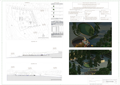
"transformation of a cadastral parcel with cartographic format into an IFC-openBIM file"
Work Phase: Technical-Economic Feasibility Project
Procurement Code Legislative Decree 36/2023 and Legislative Decree 209/2024 [IT]:
· The Technical-Economic Feasibility Project is supported by the adoption of digital information management methods and tools (Building Information Modeling), integrated with geographic information systems (Geographical Information System – GIS.)
What does the IFC-OpenBIM file contain?
A) Tree Legend;
B) Earth Movement Legend;
C) Correspondence with UNI regulations.
UNI 11337-1:2017:
n. 2 Zones Homogeneous Functional Area – AFO
· square · roads
n. 2 Zones Homogeneous spatial area – ASO
· playground · recreation area
- Relational Graphic Model (BIM)
UNI 11337-4:2017 – Information Flow:
L1 – in the process of being shared.
Terrain
- DTM – contour lines
- LOD B: · Encumbrance
Terrain – surrounding area
- LOD C: · Roads
Architectural
- LOD C:
· Envelope · Horizontal envelope · Curved wall
· Body of water · Horizontal filling · Lamppost · Garden bench
· Game table · Pull-up bars · Sandbox · Steel parasol · Waste bin
· Swing · Playground
UNI 11337:5-2017:
LC1 – Coordination level;
LV1 – Verification level (V1).
Graphic model of urban planning and reuse.
[IT]
Fase dell’opera: Progetto di Fattibilità Tecnico Economica
Codice Appalti D.Lgs. 36/2023 e D.Lgs. 209/2024 [IT]:
· Il Progetto di Fattibilità Tecnico Economica è supportato dall’adozione dei metodi e strumenti di gestione informativa digitale (Building Information Modeling), integrati con i sistemi informativi geografici (Geographical Information System – GIS.)
Cosa contiene il file IFC-OpenBIM?
A) Legenda Alberi;
B) Legenda Movimento Terra;
C) Corrispondenza con normativa UNI.
UNI 11337-1:2017:
n. 2 Zona Ambito funzionale omogeneo – AFO
· piazza · strade
n. 2 Zone Ambito spaziale omogeneo – ASO
· parco giochi · area svago
- Modello Grafico Relazionale (BIM)
UNI 11337-4:2017 – Flusso Informativo:
L1 – in fase di condivisione.
Terreno
- DTM – curve di livello
- LOD B: · Ingombro
Terreno – zona circostante
- LOD C: · Strade
Architettonico
- LOD C:
· Involucro · Involucro orizzontale · Muretto curvo
· Specchio d’acqua · Riempimento orizzontale · Lampione · Panca da giardino
· Tavolo da gioco · Sabbiera · Parasole in acciaio
· Altalena · Parco giochi
UNI 11337:5-2017:
LC1 – Livello di coordinamento;
LV1 – Livello di verifica (V1).
Modello grafico di pianificazione e riuso urbano.
#GIS #BIM #cadastralparcel #kml #shp #gpkg #IFC #openBIM #urbanfuniture #landsurveyor #digitalmapping #3dmodeling #UNI11337 #earthmovement #DTM #tree #Edificius #architectural #recreationarea #LOD


Nessun commento:
Posta un commento