
𝐖𝐡𝐚𝐭 𝐚𝐫𝐞 𝐝𝐫𝐨𝐩-𝐝𝐨𝐰𝐧 𝐦𝐞𝐧𝐮𝐬?🏃♂️
In short.. with these menus by clicking on a field you can only choose among the various elements inserted in the list what to insert and therefore without having to type manually.⌨️
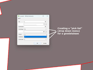
Even with 𝕘𝕖𝕠 𝕕𝕒𝕥𝕒𝕓𝕒𝕤𝕖𝕤, therefore with QGIS and ArcGIS, it is possible to develop and preset a list of elements that we can choose without having to type manually and copy and paste, therefore without making typing errors or introducing spaces.😕
Lately I have had clients who want to develop a geodatabase with many fields with drop-down lists composed of elements that allow you to fill the field based on what is entered in the drop-down menu, thus speeding up the compilation of the fields.🗃️😀
I have carried out this activity for clients in the field of fiber optics, real estate agencies, agricultural companies and urban planning studios who preferred to create a drop-down list, without having to write the same element every time or copy and paste.📶🏙️🧑🌾🏛️
The geodatabase is a territorial database that contains information on the geometry (point, polygon or line) that geolocalizes an object, building, land or natural element present in the territory.🌲🐿️🏡🏖️
This allows to standardize the language on the descriptions of a type of object, and therefore make the geodatabase more shareable among all the actors interested in carrying out the work.🤖🎯
Reducing the times and standardizing the language to facilitate the protagonists in carrying out the work is my main task.⌚⏳👏
For more information you can contact me through link by clicking on the image below.↕️⬇️
Thank you for reading and do not hesitate to contact me.
fiberoptics realestateagencies agriculturalcompanies geodatabase qgis arcgis
dataanalysis datavisualization spatialquery geospatialanalysis dropdownmenu
quickcompilation sqlquery digitalmapping geographicinformationsystem
Nessun commento:
Posta un commento